
On Tuesday, I took on what is widely recognised as New Zealand’s greatest one day walk and certainly the most popular; the Tongariro Alpine Crossing. It’s a 20 kilometre/12 mile trek across an extremely unique volcanic landscape in the middle of New Zealand’s north island.
The area is home to three active volcanoes, the most recognisable of which being Mt Ngaurahoe; more widely known as the menacing Mt Doom from Lord of the Rings! As the walk progressed, it was quite evident how the peaks and craters of Tongariro National Park could be the inspiration for the evil realm of Mordor. It was just so fitting.
Preparation
You do need to be relatively fit to do this trek, capable of clambering up and over rocks during steep climbs and comfortable with loose ground on steep descents. You will also need to make sure you’re wearing suitable attire and that you take a bag with some essential gear for the trip. I wore trainers (hiking boots are recommended but I was fine with trainers), sports shorts and a standard cotton t-shirt; however, you WILL need additional layers for when you reach the high points of the track. Here’s everything I took for the walk:
- Jogging bottoms/trackies (quick dry material) – didn’t use them
- Thick jacket
- Waterproof rain mac
- 2 powerade drinks
- 1.5 litre bottle of water
- Small 500ml bottle of water
- 2 oat bars
- 1 chocolate bar
- Ham salad wrap
- A few more bits of food that I didn’t eat
- 1 ice pack to keep my drinks cool
- Camera
- Sunglasses
I definitely had everything I needed there, but I had a stunning morning for my walk – I would probably have been wishing for more layers on a colder/wetter day.
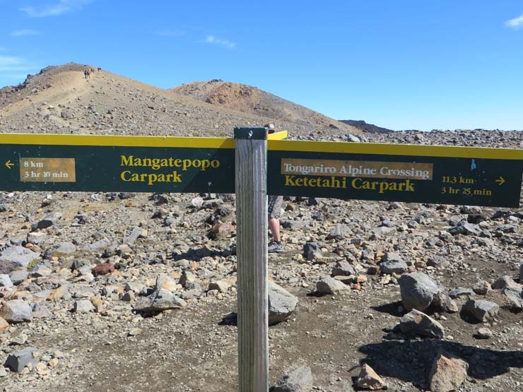
Anyway, first things first, the main track is a point-to-point, starting at the Mangatepopo car park and ending at the Ketetahi car park on the other side. Because of this, you need to think about your transport. Most of the nearby accommodation run services for the crossing, including The Park Lodge where we were staying right in National Park Village. I’d already taken advantage of a GrabOne deal a couple of months ago which included two nights in a hotel, breakfasts, transfers to and from the crossing and a packed lunch! So I was all set.
The bus dropped us off at 8am and informed us that we would be picked up at the end of the track at 3:30pm. When I say ‘us’, I mean the group that came from my accommodation (Hannah didn’t think she was up to the demands of the track due to her dodgy balance and the fact she had just recovered from a lung infection (pneumonia) – having completed it, I think her fears were probably justified).
The First Stretch
After leaving the bus, I powered straight into the trek. I was slightly anxious of how difficult I might find the demands of the track due to my complete lack of preparation and the minimal exercise I’ve done generally in the past 12 months, but I began the walk feeling pumped and determined.
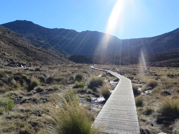
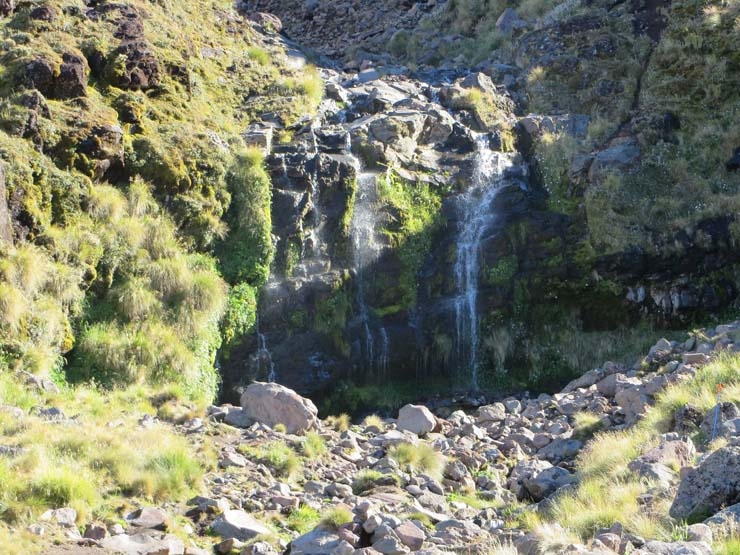
The first hour or so is fairly friendly, with the odd short, rocky climb but for the most part it was nice, level wooden paths. Then you come to your first real point of interest – Soda Springs. This is a small waterfall, just a short 300m diversion from the main track. To be honest, this was a bit disappointing as it was smaller and less impressive than it looked in the pictures I’d seen. So I pressed on to the next part of track – arguably the hardest section.
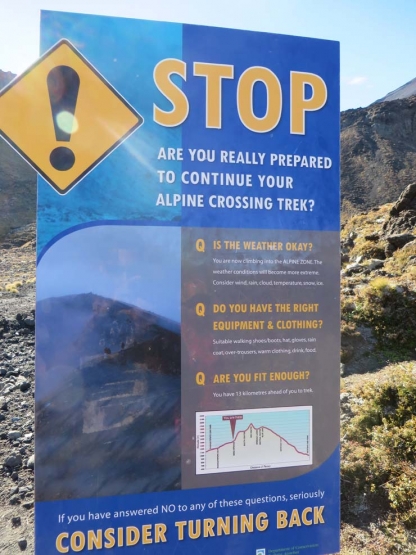
The Devil’s Staircase
The next section begins with a warning sign, ensuring you are fully aware of the challenge ahead and even suggesting that you turn back if you don’t meet the criteria outlined.
I’d read about this part before and although it was indeed a bitch, I’m pleased to say it wasn’t as difficult as I’d anticipated. It is a steep ascent up a combination of paths and staircases to the base of Mt Ngaurahoe.
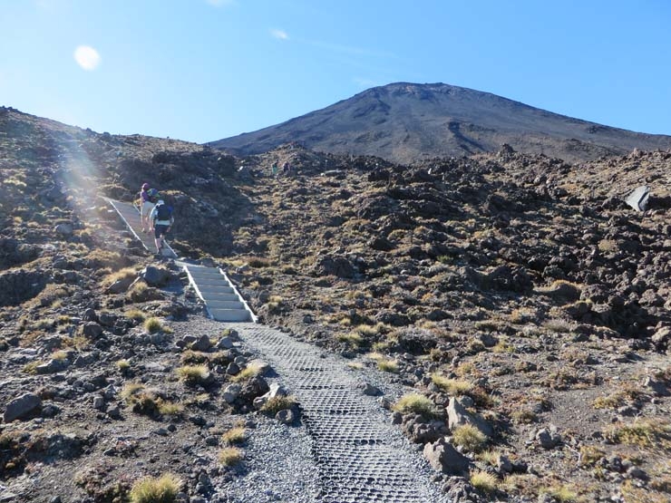
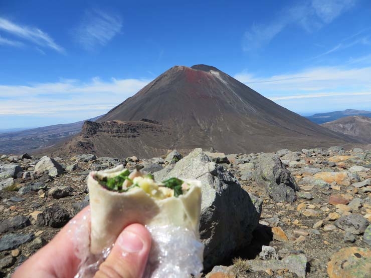
After about 45 minutes, including several photo stops which were a good excuse to get some breath back, I reached the top – a glorious moment indeed! It’s from this point that Mt Ngaurahoe (Mt Doom) looks most impressive as you stare in awe from its base.
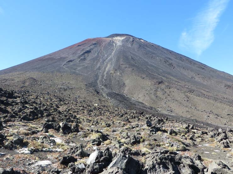
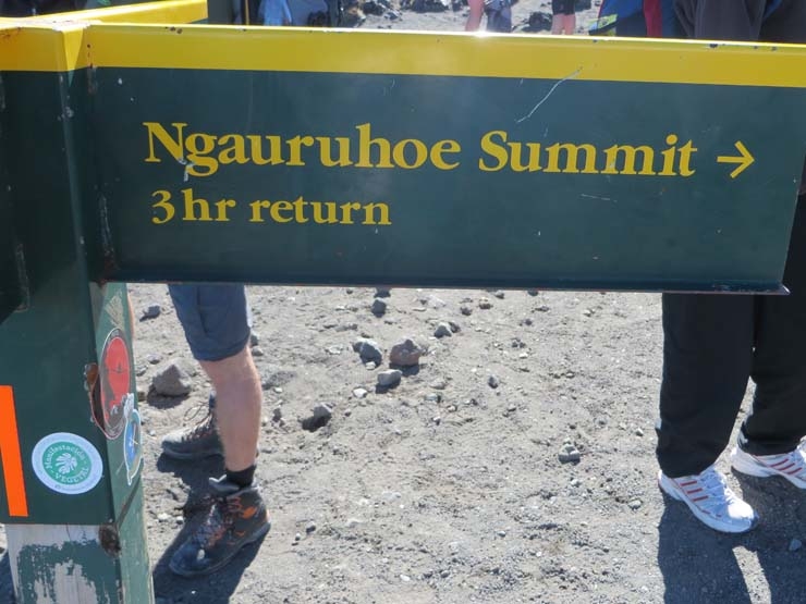
For the extremely fit and experienced (and probably insane), this is where you can take a detour from the main route to climb the mountain itself – just a 3 hour addition to the core track!
South Crater
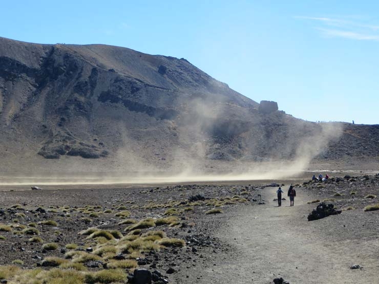
After a short pit-stop, I pressed on to the next section, which was a nice, flat walk through the middle of a giant crater. It really was a huge open space and this is subsequently where the wind began to gather some serious pace.
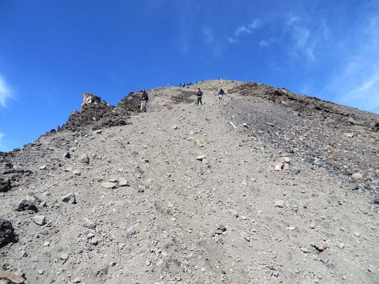
As you reach the far end of the crater, you then literally have to climb out of it. This bit was pretty tough as the path seemed to disappear in places, leaving you to simply clamber over large rocks to continue the steep climb. Fortunately, I love clambering over rocks!
As I reached the top and climbed out of the crater, I was absolutely battered by ridiculous gales! About 30 minutes earlier, I was sweating under the scorching sun after finishing the devil’s staircase – now I was standing in thunderous wind (the type that gives you an instant cold), desperately rummaging through my bag for my jacket and mac. A hindsight tip – put these layers on before you climb out of the crater! I got them on eventually but only after much wrestling as the wind tried its best to whisk them away. If I’d have let go, they would certainly have been long gone. Such was the strength of this wind that I was even clutching onto my camera when taking pictures as I genuinely felt that the wind would have taken it if I’d let go.
The next section was one of the toughest parts of the trek as not only was it a steep climb up and over the rocks with very few bits of recognisable track, but the huge winds were also persisting as the elevation and exposure increased.
Half Way!
Thankfully, I soon reached a large, rocky flat area, just below the highest point of the track. This moment was even more sweet as I realised that this was just about the half way point! But not only that, it also meant that the long gruelling climbs were almost over, with long descents making up the majority of the second half of the walk.
With this being half way, I decided that this was as good a time as any to stop for some lunch. So I found a comfortable rock to perch on and ate my wrap, with the surreal sight of Mt Doom looming right in front of me.
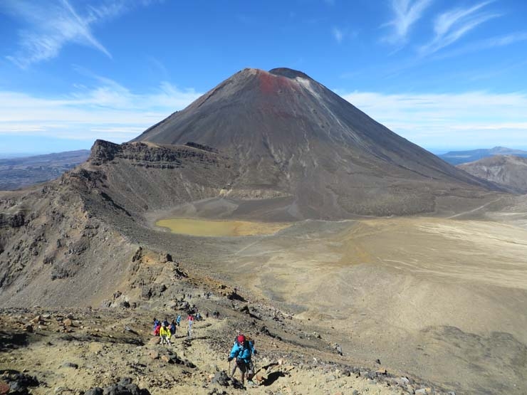
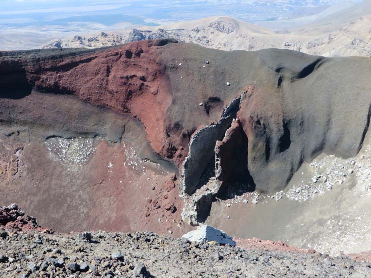
Red Crater
The next 40 minutes or so was probably my favourite part of the entire track! From where I stopped for lunch, it was a short climb up to the track’s highest point, from which I stood over the incredible sight of the Red Crater to my right hand side. It is literally a huge red coloured crater, but it has one very distinguishable feature which – just to lower the tone a little – bares a striking resemblance to a certain part of the female anatomy!
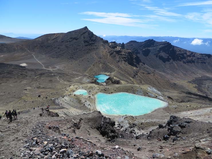
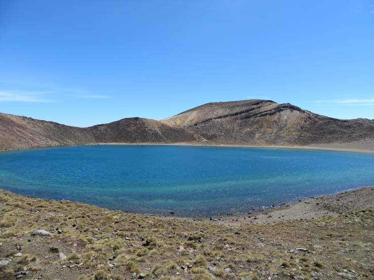
The Emerald Lakes
From the track’s peak, not only did I have this treat on my right, but right in front of me appeared one of the most surreal sights I will ever see. The Emerald Lakes – three small pools in the midst of all this rugged volcanic terrain that took on unbelievably vivid shades of light blue. For me, this was one of the trek’s biggest draws as I read up on it previously – and I’m pleased to say it did not disappoint!
I stared on in awe before beginning a short but sharp decline down from the top edge of red crater. It was this short decline, with the almost mirage like lakes in front of me, that I remember as my favourite part of the track. However, it was also a section which seemed to trouble many and I can imagine others declaring the opposite to me and suggesting it may be the worst part of the track.
It was basically a very steep decline with extremely loose ground underfoot. You have very little control over your momentum as your footing is taken away by the loose dirt and rocks beneath. However, this can also be used to your advantage if you’re up for being a little braver. I simply strode down the path, gaining 2 to 3 metres with each step as I allowed the loose dirt and gravity to do the work for me! It was really quite fun, literally sliding down the mountain towards the emerald lakes at the bottom.
As I got nearer the lakes, I was amazed how they maintained their surreal colours, even right up close. I was expecting the magic to wear off when I got right down next to them, but even as I stood on the water’s edge the blue was perhaps even more vivid than it appeared from afar. Truly breathtaking and worth the 12 mile hike alone.
Central Crater and Blue Lake
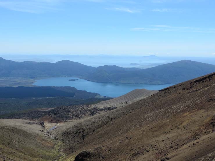
After a lengthy stop around the emerald lakes, I pressed on to the next section which took me through another crater, only a little less vast than the first one. As I climbed out of the crater I was rewarded with another stunning sight in the form of Blue Lake, which is… well, a blue lake! It’s much larger than the emerald lakes (which I would describe as pools) and not quite as surreal in terms of colour, but it is still a beautiful shade of blue and unbelievably clear.
The Start of the Big Descent
I walked around the near edge of the lake and on to another short climb. For me this was around the 4 hour mark and looking back on it now, I’d say the best of the track was behind me at this point. As I reached the top of this latest climb I was rewarded with extensive views over the landscape in front of me and the lakes further out, with the views extending as far as the eye could see. This was essentially the beginning of a very loooong descent to the end of the track.
From here on in, there were a few points of interest but nothing mind numbingly awesome like I’d seen so far. There were several signs ensuring that I was aware that the area is volcanically active and outlining the parts that should not be approached. I even learned that there was an eruption from one of the craters in 2012, which was its first significant eruption since 1896! So the dangers are very real, highlighted by further signs explaining what to do if an eruption occurs.
The Final Stretch
The long path weaved its way down the mountains very gradually for the foreseeable future, offering a pit-stop at Ketetahi Hut along the way which has toilets (long-drop) and shelter if needed. From there the path continued to wind down the mountain as the surrounding terrain got more and more green and grew taller and taller.
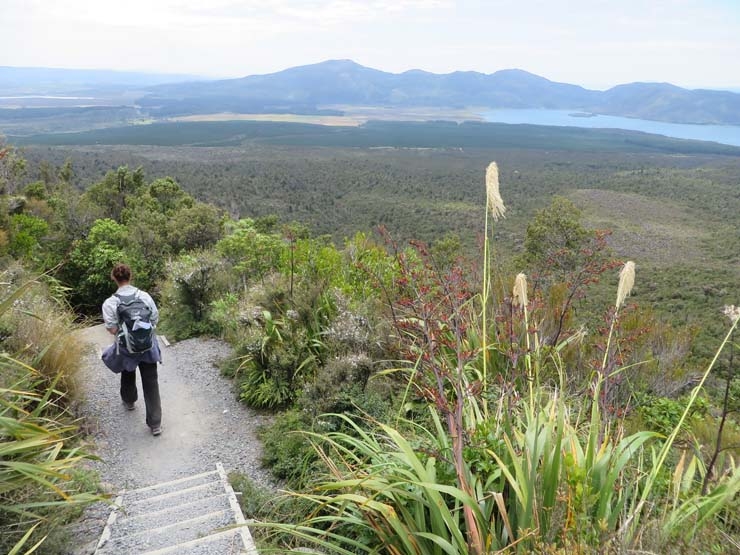
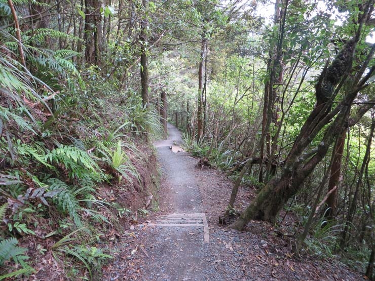
Eventually you enter full on forest for the final 45 minute stretch. It was a glorious moment as I realised I was on the home straight and the air around me suddenly became infinitely fresher and cooler thanks to the vegetation that I was now enclosed within.
The final half an hour or so was very long as I felt so close to the end yet so far for so much of the final stretch. Soon enough though I heard the sweet sound of roaring bus engines and I turned the final corner to see about 50 shattered bodies scattered about the place, all waiting for their various transport.
Surprisingly, I felt completely fine – no nagging pains or sore spots and I didn’t feel like I needed to collapse! The walk is supposed to take 6.5 hours without stops, but I completed it in 6 hours total – probably because I was doing it solo, which I think leads you to walk at a quicker pace than you would with company. I was pleased to have finished, but my early finish meant I then had a 90 minute wait for my transport! Not what you want when you’re knackered, sweaty and very much in need of a shower! But I took advantage of the situation and kicked back on the grass until my bus arrived.
Having felt fine at the end, the muscles then obviously tightened later that night after long sit downs. My legs were also very aware of the work they’d done over the next couple of days! But generally, I’m pleased with how I did and it was 100% worth doing. An absolutely amazing experience and something I will never forget.